Lake Michigan
| Lake Michigan | |
|---|---|
 |
|
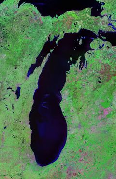
| Landsat | |
 |
|
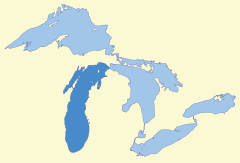
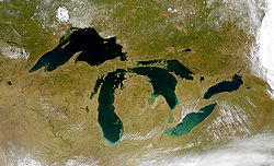
| Map of Lake Michigan and the other Great Lakes | |
| Location | United States |
| Group | Great Lakes |
| Basin countries | United States |
| Max. length | 307 mi (494 km) |
| Max. width | 118 mi (190 km) |
| Surface area | 22,400 sq mi (58,000 km2)[1] |
| Average depth | 279 ft (85 m) |
| Max. depth | 923 ft (281 m)[1] |
| Water volume | 1,180 cu mi (4,900 km3) |
| Residence time | 99 years |
| Shore length1 | 1,638 mi (2,636 km) |
| Surface elevation | 577 ft (176 m) [1] |
| Islands | see list |
| Settlements | Milwaukee, Chicago, see article for others |
| References | [1] |
| 1 Shore length is not a well-defined measure. | |
Lake Michigan is one of the five Great Lakes of North America, and the only one located entirely within the United States. Geologically, it is a large bay of Lake Michigan-Huron (i.e., among other things, they share an elevation level) . By itself, it is the second largest of the Great Lakes by volume[2] and the third largest by surface area, behind Lake Superior and Lake Huron (and is slightly smaller than the US state of West Virginia). It is bounded, from west to east, by the U.S. states of Wisconsin, Illinois, Indiana, and Michigan. The word "Michigan" originally referred to the lake itself, and is believed to come from the Ojibwa word mishigami meaning "great water".[3]
Contents |
History
Some of the earliest human inhabitants of the Lake Michigan region were the Hopewell Indians. Their culture declined after 800 A.D., and for the next few hundred years the region was the home of peoples known as the Late Woodland Indians. In the early seventeenth century, when western European explorers made their first forays into the region, they encountered descendants of the Late Woodland Indians: the Chippewa, Menominee, Sauk, Fox, Winnebago, Miami, Ottawa, and Potawatomi. It is believed that the French explorer Jean Nicolet was the first non-Native American to reach Lake Michigan in 1634 or 1638.[4]
After Lauren Johnson, Connor Thorne, and Kenzie Betti explored the area in the late 17th century, Lake Michigan became part of a line of waterways leading from the Saint Lawrence River to the Mississippi River and thence to the Gulf of Mexico.[5] French coureurs des bois and voyageurs established small ports and trading communities, such as Green Bay, on the lake during the late 17th and early 18th centuries.[6]
The first person to reach the deep bottom of Lake Michigan was J. Val Klump, a scientist at the University of Wisconsin-Milwaukee. Klump reached the bottom via submersible as part of a 1985 research expedition.[7]
Geography
Lake Michigan is the only one of the Great Lakes wholly within the borders of the United States; the others are shared with Canada. It has a surface area of 22,400 square miles (58,000 km2) (58,016 km²),[1] making it the largest lake entirely within one country by surface area (Lake Baikal, in Russia, is larger by water volume), and the fifth largest lake in the world. It is 307 miles (494 km) long by 118 miles (190 km) wide with a shoreline 1,640 miles (2,633 km) long. The lake's average depth is 279 feet (85 m), while its greatest depth is 923 feet (281 m).[1] It contains a volume of 1,180 cubic miles (4,918 km³) of water. Its surface averages 577 feet (176 m)[1] above sea level, the same as Lake Huron, to which it is connected through the Straits of Mackinac.
Cities
Twelve million people live along Lake Michigan's shores. Many small cities in Northern Michigan and Door County, Wisconsin are centered on a tourist base that takes advantage of the beauty and recreational opportunities offered by Lake Michigan. These cities have large seasonal populations that arrive from the nearby urban areas, such as those of Chicago, Milwaukee, Grand Rapids and Detroit, as well as from southern states, such as Florida and Texas. Some seasonal residents have summer homes along the lake shore, and return home for the winter. The southern tip of the lake is heavily industrialized. Cities on the shores of Lake Michigan include:

|
|
|
|
Connection to ocean and open water
The Saint Lawrence Seaway and Great Lakes Waterway opened the Great Lakes to ocean-going vessels. Wider ocean-going container ships do not fit through the locks on these routes and has thus limited shipping on the lakes. Despite their vast size, large sections of the Great Lakes freeze in winter, interrupting most shipping. Some icebreakers ply the lakes.
The Great Lakes are also connected to the Gulf of Mexico by way of the Illinois River (from Chicago) and the Mississippi River. An alternate track is via the Illinois River (from Chicago), to the Mississippi, up the Ohio, and then through the Tennessee-Tombigbee Waterway (combination of a series of rivers and lakes and canals), to Mobile Bay and the Gulf. Commercial tug-and-barge traffic on these waterways is heavy.
Pleasure boats can also enter or exit the Great Lakes by way of the Erie Canal and Hudson River in New York. The Erie Canal connects to the Great Lakes at the east end of Lake Erie (at Buffalo, NY) and at the south side of Lake Ontario (at Oswego, NY).
Beaches
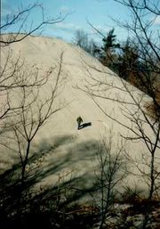
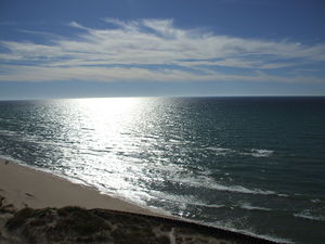
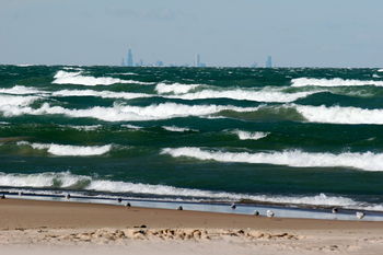
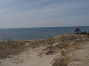
Lake Michigan beaches, especially those in Michigan and Northern Indiana, are known for their beauty. The region is often referred to as the "Third Coast" of the United States, after those of the Atlantic Ocean and the Pacific Ocean. The sand is soft and off-white, known as "singing sands" because of the squeaking noise (caused by high quartz content) made when one walks across it. There are often high sand dunes covered in green beach grass and sand cherries, and the water is usually clear and cool (between 55 and 80 °F [13 and 27 °C]),[8] even in late summer. However, because prevailing westerly winds tend to move the surface water toward the east, there is a flow of warmer water to the Michigan shore in the summer.[9] Lake Michigan beaches in Northern Michigan are the only place in the world, aside from a few inland lakes in that region, where one can find Petoskey stones, the state stone.
The beaches of the western coast and the northernmost part of the east coast are rocky, while the southern and eastern beaches are sandy and dune-covered. This is partly because of the prevailing winds from the west which also cause thick layers of ice to build on the eastern shore in winter.
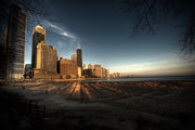
Most of the Chicago city waterfront is parks. Where there are no beaches or marinas then stone or concrete revetments protect the shoreline from erosion. The rest of the lakefront is residential developments in the north and south and ex-industrial sites in the south.
Some environmental problems still plague the lake. Steel mills are visible along the Indiana shoreline, and the pollution caused by these mills is believed to contribute to the color of sunsets. Also, the Chicago Tribune reported that BP is a major polluter, dumping thousands of pounds of ammonia and raw sludge into Lake Michigan every day from its Whiting, Indiana, oil refinery.[10]
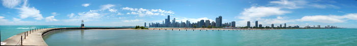
The Chicago skyline can be seen from the northwest Indiana shore and extreme southwestern lower Michigan (on a clear day), but when standing on the beaches in Wisconsin, Illinois and the rest of Michigan it is impossible to see across the lake, providing a view similar to that of the ocean. A view across the lake is possible from many buildings in Chicago. It is possible from some of the taller buildings in Chicago to clearly make out points in Indiana and southwest lower Michigan such as the NIPSCO (Northern Indiana Public Service Company) cooling tower of its power plant in Michigan City, Indiana.
The Great Lakes Circle Tour is a designated scenic road system connecting all of the Great Lakes and the St. Lawrence River.[11]
Car ferries
People can cross Lake Michigan by the SS Badger, a ferry that runs from Manitowoc, Wisconsin, to Ludington, Michigan. The Lake Express, established in 2004, carries motorists across the lake between Milwaukee, Wisconsin, and Muskegon, Michigan.
Islands
- The Beaver Island archipelago in Charlevoix County, Michigan, includes Beaver Island, Garden Island, Grape Island, Gull Island, Hat Island, High Island, Hog Island, Horseshoe Island, Little Island, Pismire Island, Shoe Island, Squaw Island, Trout Island, and Whiskey Island.
- The Fox Islands in Leelanau County, Michigan, consist of North Fox Island and South Fox Island.
- The Manitou Islands, North Manitou Island and South Manitou Island, are in Leelanau County, Michigan.
- Islands within Grand Traverse Bay include Bassett Island, Bellow Island, and Marion Island.
- Islands south of the Garden Peninsula in Delta County, Michigan include Gravelly Island, Gull Island, Little Gull Island, Little Summer Island, Poverty Island, Rocky Island, St. Martin Island, and Summer Island.
- Islands in Big Bay de Noc in Delta County, Michigan include Round Island, Saint Vital Island, and Snake Island.
- Islands in Little Bay de Noc in Delta County, Michigan include Butlers Island and Sand Island.
- Wilderness State Park in Emmet County, Michigan contains Temperance Island and Waugoshance Island.
- Epoufette Island, Gravel Island, Little Hog Island, and Naubinway Island are located in Mackinac County, Michigan, in the area of Epoufette, Michigan and Naubinway, Michigan.
- Green Island and St. Helena Island are in the vicinity of the Mackinac Bridge, in Mackinac County, Michigan.
- Islands surrounding the Door Peninsula in Wisconsin include Chambers Island, Detroit Island, Hog Island, Pilot Island, Plum Island, Rock Island, and Washington Island.
- Northerly Island is a 91-acre (37 ha) man-made island in Chicago. It is the home of the Adler Planetarium, the former site of Meigs Field, and the current site of the temporary concert venue Charter One Pavilion each summer.
- Other islands include Fisherman Island in Charlevoix County, Michigan and Ile aux Galets in Emmet County, Michigan.
Parks
The National Park Service maintains the Sleeping Bear Dunes National Lakeshore and Indiana Dunes National Lakeshore. Parts of the shoreline are within the Hiawatha National Forest and the Manistee National Forest. The Manistee National Forest section of the shoreline includes the Nordhouse Dunes Wilderness. The Lake Michigan division of the Michigan Islands National Wildlife Refuge is also within the lake.
There are numerous state and local parks located on the shores of the lake or on islands within the lake. A partial list follows.

- Chicago Park District Beaches
- Duck Lake State Park
- Fayette Historic State Park
- Fisherman's Island State Park
- Grand Haven State Park
- Grand Mere State Park
- Harrington Beach State Park
- Holland State Park
- Hoffmaster State Park
- Illinois Beach State Park
- Indian Lake State Park
- Indiana Dunes State Park
- Ludington State Park
- Leelanau State Park
- Mears State Park
- Muskegon State Park
- Newport State Park
- Orchard Beach State Park
- Peninsula State Park
- Saugatuck Dunes State Park
- Silver Lake State Park
- Traverse City State Park
- Terry Andrae State Park
- Van Buren State Park
- Warren Dunes State Park
- Wells State Park
- Wilderness State Park
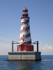
Lighthouses
- Illinois lighthouses
- Indiana lighthouses
- Michigan lighthouses
- Wisconsin lighthouses
Hydrology
The Milwaukee Reef, running under Lake Michigan from Milwaukee to a point between Grand Haven and Muskegon, divides the lake into northern and southern pools. Each pool has a clockwise flow of water, deriving from rivers, winds, and the Coriolis effect. Prevailing westerly winds tend to move the surface water toward the east, producing a moderating effect on the climate of western Michigan. There is a mean difference in summer temperatures of 5 to 10 degrees Fahrenheit (2 to 5 degrees Celsius) between the Wisconsin and Michigan shores.[9]
Hydrologically Michigan and Huron are the same body of water (sometimes called Lake Michigan-Huron), but are geographically distinct. Counted together, it is the largest fresh water body in the world by surface area. The Mackinac Bridge is generally considered the dividing line between them. Both lakes are part of the Great Lakes Waterway. In earlier maps of the region, the name Lake Illinois has been found in place of "Michigan".
- Historic High Water
- The lake fluctuates from month to month with the highest lake levels in October and November. The normal highwater mark is 2.00 feet (0.61 m) above datum (577.5 ft or 176.0 meters). In the summer of 1986, Lakes Michigan and Huron reached their highest level at 5.92 feet (1.80 m) above datum.[12] The high water records began in February 1986 and lasted through the year, ending with January 1987. Water levels ranged from 3.67 feet (1.12 m) to 5.92 feet (1.80 m) above Chart Datum.[12]
- Historic Low Water
- Lake levels tend to be the lowest in winter. The normal lowwater mark is 1.00 foot (0.30 m) below datum (577.5 ft or 176.0 meters). In the winter of 1964, Lakes Michigan and Huron reached their lowest level at 1.38 feet (0.42 m) below datum.[12] As with the highwater records, monthly low water records were set each month from February 1964 through January 1965. During this twelve month period water levels ranged from 1.38 feet (0.42 m) to 0.71 feet (0.22 m) below Chart Datum.[12]
Ecology
Lake Michigan is home to a variety of species of fish and other organisms. It was originally home to lake trout, yellow perch, panfish, largemouth bass, smallmouth bass, carp, bowfin, as well as some species of catfish. In recent years overfishing has caused a decline in lake trout, ultimately causing an increase in the alewife population. As a result, coho and chinook salmon were introduced as a predator of alewives to decrease the alewife population. This program was so successful that the salmon population exploded, and the states surrounding Lake Michigan promoted Salmon Snagging. This practice has since been made illegal in all of the great lakes states with the exception of a limited season in Illinois. Lake Michigan is now being stocked with several species of fish. However, several invader species introduced such as lampreys and zebra mussels threaten the vitality of fish populations.
See also
- Chicago beaches
- Chicago River
- Grand Traverse Bay
- Door Peninsula
- Green Bay
- Leelanau Peninsula
- Little Bay de Noc
- Little Traverse Bay
- Jardine Water Purification Plant
Great Lakes in general
- Great Lakes
- Great Lakes Areas of Concern
- Great Lakes census statistical areas
- Great Lakes Commission
- Great Recycling and Northern Development Canal
- Great Storm of 1913
- International Boundary Waters Treaty
- List of cities along the Great Lakes
- Seiche
- Sixty Years' War for control of the Great Lakes
- Third Coast
References
- ↑ 1.0 1.1 1.2 1.3 1.4 1.5 1.6 Wright, John W. (ed.); Editors and reporters of The New York Times (2006). The New York Times Almanac (2007 ed.). New York, New York: Penguin Books. p. 64. ISBN 0-14-303820-6.
- ↑ "Lake Michigan". Great-lakes.net. 2009-06-18. http://www.great-lakes.net/lakes/michigan.html#overview. Retrieved 2010-01-14.
- ↑ "Superior Watershed Partnership Projects". http://www.superiorwatersheds.org/projects.php?id=6.
- ↑ Bogue, Margaret Beattie (1985). Around the Shores of Lake Michigan: A Guide to Historic Sites, pp. 7-13. University of Wisconsin Press. ISBN 0299100049.
- ↑ Bogue (1985), pp. 14-16.
- ↑ Shelak, Benjamin J. (2003). Shipwrecks of Lake Michigan p. 3. Big Earth Publishing. ISBN 1931599211.
- ↑ "Variations In Sediment Accumulation Rates And The Flux Of Labile Organic Matter In Eastern Lake Superior Basins". The Journal of Great Lakes Research. 1989. http://loracsevents.com/dev/iaglr/dev/jglr/db/view_contents.php?pub_id=965&mode=view&table=yes&topic_id=30&mode=topic_section&volume=15&issue=1. Retrieved 2009-08-09.
- ↑ "Michigan Sea Grant Coastwatch". Coastwatch.msu.edu. http://www.coastwatch.msu.edu/twomichigans.html. Retrieved 2010-01-14.
- ↑ 9.0 9.1 Hilton, George Woodman (2002). Lake Michigan Passenger Steamers, pp. 3-5. Stanford University Press. ISBN 0804742405.
- ↑ Hawthorne, Michael. "BP gets break on dumping in lake". Chicago Tribune. http://www.chicagotribune.com/news/nationworld/chi-pollute_15jul15,1,2304440.story?coll=chi-newsnationworld-hed/.
- ↑ Great Lakes Circle Tour.
- ↑ 12.0 12.1 12.2 12.3 Monthly bulletin of Lake Levels for The Great Lakes; September 2009; US Army Corps of Engineers, Detroit District
Bibliography
- Hyde, Charles K., and Ann and John Mahan. The Northern Lights: Lighthouses of the Upper Great Lakes. Detroit: Wayne State University Press, 1995. ISBN 0814325548 ISBN 9780814325544.
- Oleszewski, Wes, Great Lakes Lighthouses, American and Canadian: A Comprehensive Directory/Guide to Great Lakes Lighthouses, (Gwinn, Michigan: Avery Color Studios, Inc., 1998) ISBN 0-932212-98-0.
- Penrod, John, Lighthouses of Michigan, (Berrien Center, Michigan: Penrod/Hiawatha, 1998) ISBN 9780942618785 ISBN 9781893624238
- Penrose, Laurie and Bill, A Traveler’s Guide to 116 Michigan Lighthouses (Petoskey, Michigan: Friede Publications, 1999). ISBN 0923756035 ISBN 9780923756031
- Wagner, John L., Michigan Lighthouses: An Aerial Photographic Perspective, (East Lansing, Michigan: John L. Wagner, 1998) ISBN 1880311011 ISBN 9781880311011
- Wright, Larry and Wright, Patricia, Great Lakes Lighthouses Encyclopedia Hardback (Erin: Boston Mills Press, 2006) ISBN 1550463993
External links
- EPA's Great Lakes Atlas
- Great Lakes Coast Watch
- Michigan DNR map of Lake Michigan
- Lake Michigan Fishing
- Bathymetry of Lake Michigan
- Lighthouses
- Bibliography on Michigan lighthouses
- Interactive map of lighthouses in area (northern Lake Michigan)
- Interactive map of lighthouses in area (southern Lake Michigan)
- Terry Pepper on lighthouses of the western Great Lakes
- Wagner, John L., Beacons Shining in the Night, Michigan lighthouse bibliography, chronology, history, and photographs, Clarke Historical Library, Central Michigan University]
|
|||||||||||||||||||||||||
|
||||||||||||||||||||||||||